THE JOMON LIGHT HOUSE
Lighthouse Experiments and the Jomon language
Furuta Takehiko
88-32 Nakakaido, Mozumemachi, Muko-shi, Kyoto 617-0001 , Japan
cic68650@syd.odn.ne.jp
1
One of the most important points in the Japanese ancient history has now been left behind. No schoolbook takes up this at all. It is the megaliths cluster that is the Jomon site around Ashizuri Point area, including the Toujin Daba site at the tip of the Point located in Tosashimizu city, Kochi Prefecture.
It is important that he Jomon site around Ashizuri Point is the only where point the Kuroshio Current (the Black Current) hits the Japanese archipelago.
The Japanese archipelago used to be a part of the Asian Continent. It says that it had gradually separated from the main continent, taking a long time, and got to the present location. It was the period the human race has not yet made his appearance on the earth. However, even though man began to live along the Amur River basin such as the Khabarovsk region before long, the distance between the continent and the Japanese archipelago was still narrow. It says, even now, we can walk to Sakhalin from the continent in winter. The human race naturally came to the archipelago from the continent on foot or by boats. We cannot overlook this root when we think of Japanese history.
However, on the other hand, besides the root from the continent, there was a root from the ocean also.
The great Current of Kuroshio also must have been hitting a corner of the unmanned Japanese archipelago even before man began to live in the earth.
However, with the start of inhabitation of the human race in those islands of the ocean, they must have aspired to make magnificent trips by riding on dugouts or logs, relying on only their own adventurous spirit. Of course, there must have been accidental drifts. The arrival spot after the drifts was Ashizuri Point. or, there is no doubt that it was one of them at least.
2
Taking a broad view like the above, it is impossible to lose sight of the existence of the megaliths cluster extensively spread around Ashizuri Point. If we observe them, visiting each of the sites, we will have no doubt at all as to the fact that the megaliths clusters are 'artificial structures.'
'Sanretsu Seki (three row stone alignment)' is as an example. It is a style of the megaliths cluster exists scatteredly at each site in both the coasts and the inlands of Japan. It cannot be believed that such the structures as Sanretsu Seki were accidentally made by 'Natural Hands,' even the form of the structures is simple. At the stone alignment cluster of the 2nd peak (B site) of Mt.Sada, the Sanretsu Seki exists at the center, surround by the stone alignments like a stone circle. It must be obviously the man-made structures. Photographing from a hot-air balloon floating in the sky was planed and carried out. Consequently the alignments' conditions underneath the balloon floating could be ascertained and the pictures of the configuration could be taken (1).
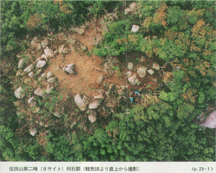
Stone alignment cluster of the 2nd peak (B site) of Sadayama
Asizurisyuhenn no Kyosekiikou (Tosashimizu City Board of Education)
And also, it was confirmed by the scholars of petrology that two of the stones in the Sanretsu Seki do not match with the direction of natural stone alignment (natural joint) shown in the precipices of this region. (2)
Also, there is a megalith in the shape of 'the female genitals' which is regarded as a 'ritual' place (a shrine) at present. In addition, a long stone, of which shape is a huge penis, is also arranged there. It is known all of these male and female stones were the embodiment of the religious of the Paleolithic and the Jomon periods in the Japanese archipelago.
Another notable structure is the Kamegata Ishi (big turtle shaped stone). Its shape is simple. However, it is the figure of a large sea turtle which arrived at this place on the shore as the egg-laying site, after a long journey. It is fully conceivable that this turtle was deified as 'a god', since it is a big living creature which comes riding on the Kuroshio Current and goes back again.
The following one point verifies that all of the above mentioned structures are ones built way back in the Jomon period. In fact, the archaeological artifacts found from the underground of this region are mostly limited to a sort of the Jomon potteries. The Yayoi potteries and the artifacts of the later periods are remarkably few. It is no doubt that the population had sharply decreased after the Jomon Period in this area, even thought it is obvious that a few inhabitants of the Yayoi and the later periods still lived in this area.
The number of the people who built and maintained such the extensive and magnificent megaliths cluster should not be small. Also, it has to be presumed that so many people needed for construction of the megaliths if it was all done manually, not automatically. And the people who maintained the workers must be much more. From the observations above, it is reasonable to conclude that the time the megaliths cluster was constructed and the rituals were conducted corresponds to the period that a lot of the Jomon potteries were found from the sites around Asizuri point (the Toujin Daba site etc).
3
The ancient country name 'Shujukoku'has almost never been mentioned before. The "Shujukoku" has been occasionally taken up in folklore, maybe because it means a 'country of midgets' in Japanese, however, they were, after all, no better than the observations with 'curious eyes.' Any reports which have the certain geographical and historical evidences of where "Shujukoku" was have hardly been found.
The word of "Shujukoku" appears in one of sentences in the article of 'Gishi Wajinden' of Sanguozhi (Records of Three Kingdoms) as a country name.
「女王國の東、海を渡る千余里、復た國有り、皆倭種なり、又侏儒國有り、其の南にあり。人の長三、四尺、女王を去る四千余里」
'Jooukoku (1) no higashi, (3) umi wo wataru sen yori(2), mata kuni ari, mina washu nari. Mata Shujukoku ari, sono minami nj ari. Hito no take san. shijyaku, jouou wo saru yonsenyori (4)' Making list of my understandings of this sentence as follows:
|
Jooukoku (Yamataikoku: ancient country in Japan) is on the area centering the coast of Hakata Bay, Fukuoka Prefecture. (3)
|
(2)
|
'Ri' means 'Tanri (unit of distance),' used in the periods of Zhou and Wei/Xijin in China. One 'Ri' is about 77m.
|
(3)
|
'Jooukoku no higash umi wo wataru senyori' tells that it is around the Kanmon Strait at Shimonoseki city (the point where Kyushu Island meets the mainland). |
(4)
|
It says that the place, which is in the south of around the Kanmon Strait, and the place 'yonsenyorj' away from 'Jooukoku (1),' is around Ashizuri Point, Kochi Prefecture. This is the 'Shujukoku.' |
(5)
|
The 'Shujukoku' is the only meet point of the Japanese archipelago and the Kuroshio Current as previously mentioned.
|
The rationality which the interpretation above has is that both (3) and (5) correspond and conform to the specific 'actual geographical features' of the Japanese archipelago. The 'Shujukoku' was the departure point of 'one year ocean voyage' toward the southeast, and it might be the merits that other places don't have.
However, the Japanese academic community has never argued the pros and cons of the presentation for the last thirty years, and they have never taken it up as a controversial issue. It is to be regretted that they have been avoiding the sincere controversies.
4
The important sentence in the article of 'Gishi WaJinden' which could be the matter of the core comes out right after it (the sentence above).'
「又裸國・黒歯國有り。復た其の東南に在り、船行一年にして至る可し」※
Mata Rakoku. Kokushikoku(9) ari, mata sono tounan ni ari. Senkou ichinen (4) (8) nishite itarubeshi'
Analyzing the sentence above is as follows:
(1)
|
A 'double year calendar (a half year counts one year)' is used on the Article Gishi Wajinden. The description of the life time of Japanese at that time is one hundred years or 80, 90 years with it. |
(2)
|
The 'double year calendar' is used in the Pacific islands (Palau etc.) even now.
|
(3)
|
The emperors' Iife(average), which is a long life of ninety years old described in Kojiki(the oldest surviving historical book recounting events of ancient earth in the Japanese language) and Nihonshoki(The Chronicles of Japan, is the second oldest book of classical Japanese history) also likely to show it. (TWO festivals in spring and autumn at present is a representative example.) |
(4)
|
'Senkou ichinen(one year voyage)' means 'half a year voyage' of the present calendar.
|
(5)
|
If a boat departs from Ashizuri Point riding on the Kuroshio Current, it would reach around Ecuador/Peru of South America. (the Kuroshio Current colliding with the Humboldt Current) |
(6)
|
According to the records of the young Japanese, two-way trip from the Japanese archipelago to San Francisco(United States of America), takes about three months. |
(7)
|
The distance from San Francisco to Ecuador/Peru is about the same as that of from the Japanese archipelago to San Francisco.
|
(8)
|
The description of 'Senkou ichinen =One year voyage(half a year)' can be correct.
|
(9)
|
'Rakoku(Luoguo: a country where naked people live), Kokushikoku(Heichigu: a country where people with black teeth live)' could be around Ecuador/Peru. |
The demonstrations above would have had the surprising evidence one after another during the past thirty years.
-
There is a report: parasites on the ancient mummy existing in South America are from Japanese (Dr. Araujo etc.) (5).
-
The viruses and genes of South American aborigines conform to those of Japanese(inhabitants of the Pacific coast).(Mr. Kazuo Tajima of Nagoya) (6).
From the above, it is obvious that the demonstration should be notable fact. However, it has not been officially disputed among the academic(Ancient history/archaeology) world.
5
An interesting theme has been reported.
After the Caucasians landed at the American Continent and moved to the west for a new world, they went up north from the West Coast and reached Alaska. Aborigines called 'Salmon Indian' were in Alaska, fishing salmons for a living. They had owned slaves that were Japanese fishermen drifted to Alaska (7).
Although the report has never been written in our schoolbooks and history books, it is very possible that
the Grand Current of Kuroshio would lead Alaska. That is the report that cannot be ignored as the irrational matter.
From the Jomon period to the present day, the Great Current called 'Kuroshio' has never ever stopped.
6
The book which has the core of the doctrine for long time and leads the magnificent theme 'the voyage of the Pacific by the Jomon people', is Early Formative Period of Coastal Ecuador: the Valdivia and Machalilla Phases, written by Emilio Estrada, Betty J. Meggers and Clifford Evans (8).
The book was published in 1965, when nobody had thought of that kind of theme yet. Mr. Estrada, who had lived in Ecuador, came up with the theme. Then he reported it to Ms. Meggers and Mr. Evans of Smithsonian Institute in Washington D.C., with the recognition: the potteries excavated in the Valdivia region were different from the others of the local area and were similar to the Jomon potteries. Mr. And Mrs. Evans visited Japan immediately and examined the Jomon potteries everywhere in Japan. He finally verified that the both potteries of Japan and Ecuador were an indivisible relation in 'diffusion.'
The precise comparative research on the 'patterns' of the potteries by Ms. Meggers and the contrast of 'Continuity(from the First to the Middle Jomon) of the pottery tradition in Japan' with 'Lack of the tradition(before the Middle Jomon) in Ecuador' by Mr. Evans and also the logical demonstrations are undeniable.
However, both the academic society of the Jomon and the general archaeologists of the United States showed the cold shoulder to the valuable presentation. Further, the Japanese society had never invited Mr. and Mrs. Evans to Japan to have public academic discussions.
7
A few essays, written by Japanese archaeologists criticize Meggers and Evans.
1. Mr. Esaka Teruya.
The Jomon potteries similar to those of Valdivia, mentioned in the book by Meggers and Evans, were excavated from the sites(Sobata, Ataka, Todoroki, Izumi etc.) along the Ariake Sea coast of Kyushu(Kumamoto Prefecture and the northwest region of Kagoshima Prefecture).
However, It is unnatural that the similarity to the Jomon potteries found in Kagoshima Prefecture in the southern end of Kyushu was not been mentioned in the book, considering the Black Current drifting Jomon people. Therefore, the similarity of both(Valdivia and Japan) is just a 'coincidence.'
2. Mr.Sahara Makoto.
The theory about 'diffusion' seems arbitrary. It does not coincide with 'Similarity to the Jomon potteries of Kyushu with those of Valdivia' (10), because some of the Jomon potteries similar to those of Valdivia illustrated in the book are from a part of southern half of 'the Kanto regions.'
3. Mr. Saito Kiyohide.
A matter of 'pottery shape' raises a contradiction of the theory of Meggers and Evans. The shapes of the Jomon potteries are generally the pointed-bottom or the deep bottom that the Valdivia potteries never have. It is unscholarly to compare 'the pattern of the potteries' without ignoring the differences of the pottery shapes (11).
All of the convincing indications would be refuted before long.
1. Mr. Esaka's Criticism.
There was a big eruption of Kikai Caldera, 6,300 to 6,400 years ago(the late Jomon) of which focus was Satsuma lwo Shima Island at the southern sea of the Kyushu region. The volcanic ashes of the eruption can be found at various places of the western region. The following situations must have been seen at that time. Most of Kagoshima Prefecture(except the northwest region) was completely destroyed. Kumamoto Prefecture and the northwest region of Kagoshima Prefecture were half-destroyed and half-survived. Since the flying direction of volcanic ashes was toward the east, the people could not escape to that direction and had to escape to the Ariake Sea of the west. When they went down to the south from the Ariake Sea, they found the Kuroshio Current.
If the incident could be considered as the origin of the problem, the weak point(contradiction) of the theory of Meggers and Evans has turned to the demonstrative power. The theory would be able to have a theme of 'the migration(on the current) of the escapees from the one big eruption.' Meggers and Evans have earnestly given importance to 'the reality the pattern of the potteries own, the significance of its completeness and the scientism. This matter was proved as a result of my actual investigation in accordance with a direct request of Meggers in autumn of 1995.
2. Mr. Sahara's criticism.
Hakone Volcano erupted 5,980 B.P.(±210, carbon-14 dating) to destroy most of Kanagawa Prefecture. The Miura Peninsula(Miura City) of Kanagawa Prefecture and the central and the southern parts of Tokyo Metropolitan were half-destroyed and half-survived. In fact, these areas were the distribution zone of the Jomon potteries in 'common with the Valdivia potteries' indicated with accuracy by Meggers and Evans. Until I confirmed this fact, both of them did not know about it (12).
3. Mr. Saito's criticism.
The shapes of the Early Jomon potteries found a lot in Southern Kyushu in recent years have reversed the common ideas of 'the conventional pottery shape' within a short time. Cylindrical potteries of chimney-shape, angular cylindrical potteries of square pillar-shape, and in-between lemon-shape potteries were found one after another. Also, jar-shape potteries and bowl-shape potteries came out from the Uenohara site, which might be a ritual place (13).
As the above, the common idea on 'pottery shape' of the Jomon potteries has been changed from solidity to fluidity. Much more, as for the Valdivia pottery, since it is 'the pottery established under an influence of the Jomon civilization,' so to speak 'the sub-Jomon pottery' rather than the 'pure Jomon pottery,' it is academically perilous to judge the existence of 'diffusion' just from simple 'pottery shape comparison.'
When the theory of Meggers and Evans was published in 1965, it had not been known that a lot of the Initial Jomon potteries were found in Southern Kyushu as mentioned above.
8
"Learning belongs to logics and demonstrations".
If this saying is correct, the theory of Meggers and Evans proposed 40 years ago must now obtain the status which is beyond the comparison with one at the time of the publication because of those verifications and new discoveries up to now.
However, the real academic world has not let it. The archaeological societies of both Japan and the United States seem, unfortunately, not only denied the academic meaning of the theory but also paid no heed or sneered.
There were a lot of samples of discoveries and theories such as Copernicus, Galileo, Darwin or Mendel, which is scientifically immortal significance at present, had been treated coldly for a long time. However, the denials and indifference damage the human race, because the academic development of later years had been stagnant or stopped by that those new theories were not reasonably evaluated.
If this report would be properly accepted, new researches in each field would be able to grow remarkably.
For example, the matters of spread and diffusion of 'the Jomon civilization' in the Japanese archipelago, the matters of diffusion and spread of the Jomon civilization to other areas of Asian continent such as China and the Korean Peninsula etc would be advanced. The sudden rise of the Humudu site of Jiang Nan (China) took place at around the time of the big eruption of Satsuma lwo Island.
As the matters of diffusion and interchange of other civilizations in the earth such as the interchanges between other continents which were difficult to expect before as the same case as Japan, would need to be re-examined with the positive logics and actual proofs.
Moreover, as for the formation and development of the Jomon civilization itself in Japan, new unexpected issues might be able to be raised.
No one knows what will be happened in consequence. And one of acceptable phenomena should not always affect other phenomena easily and immediately, which is not worth of being the name of learning. However, the cold treatment given to the theory of Meggers and Evans would become one of the best 'touchstones' for the future progress of the Jomon research.
Toujinseki looking from theUsubae observation
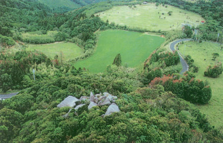
Tojin Daba looking from Toujinseki
9
The main theme is a research of the megalithic structural remains around Ashizuri Point.
The experiment was conducted to verify the roles and the significance of the structure remains in the Jomon period on November 3nd 1993.
The noticeable "Kagami lwa(mirror rock)" cluster is in the megalithic structural remains of this site, besides other remains mentioned earlier. A lot of menhir with large plane surface faces on the Pacific Ocean, in other words, looking to the Kuroshio Current coincidentally. It is not conceivable that Mother Nature accidentally forms 'the megaliths cluster which has plain surfaces facing on the specific direction.'
Therefore they must be, naturally, man-made structures. They might be built for the people on boats in the sea might look at the plane surfaces which shine by the reflected lights of the sun and the moon.
The megalithic structures named 'Kagami lwa(mirror rocks)' or 'Kagami Ishi(mirror stones)' which receive the reflected light from the sun or the moon are at various places in the Japanese archipelago. People worship and have the belief for the 'light(Komyo)'. That is 'Kagami lwa Shikou(mirror rock beliefs)'. The ancient people from Asizuri point might have the mirror rock beliefs.
The role of a 'lighthouse' could be one of the possibilities. As mentioned earlier, the Kuroshio Current comes up to the north and hits the cliff of the Ashizuri violently, and has power to easily break boats, rafts and even human being. Trying to get out of the Kuroshio Current before the collision is the only method to avoid the 'traffic accident'. Considering the speed of the Kuroshio, taking the chance and having a big effort, it is possible to escape. However, the 'timing' is the important consideration. Unless you start the escape action at the early stage which the distance from the cliff of the Ashizuri Point is still ample, the escape would not be able to be successful. The decision as soon as recognizing the existence of 'the cliff in sight' would spell the difference between life and death. The existence of the 'mirror rocks' is indispensable to play the great role as 'the Jomon lighthouse.'
An experiment was carried out to investigate how the 'mirror rocks' really play the roles.
10
The experiment was succeeded. The experiment was carried out with enough inspection repeatedly conducted since February(1-February 28th 2-April 4th,5th,6th 3-August 4th,5th,6th, 4-September 2nd (Nakamura city) 5-0ctober 25th). The boat for the experiment departed, being protected by fishing boats of the local people at 5:30 a.m. on 3rd of November. And technical experts with measuring equipments were waiting at the Toujin Daba site and the Usubae observation platform. The preparatory experiment on the sea was conducted at this sea area on the last day of October 25th.
The experiment expected following two results that 'Toujin Seki(Rock)' could shine by the reflected light of the sun or the moon from the south point of Usubae sea area, and that the reflected lights could be seen from the sea.
There were some technical problems during the process.
-
It is primarily essential to plane the megalith and polish the surface before the experiment, because the mirror rocks must had been thoroughly polished by the ancient people when the 'Jomon lighthouse' was 'active' in the Jomon period.
-
However the request of 'the preservation of natural condition' of Mother Nature from government
restrained the best method. A lot of silver papers(reflectors for filming) for sticking on the entire surfaces of 'Toujin Seki' as the subject for the measurement were used as replacement after all.
-
After measuring the brightness of the 'rock' itself of 'TouJin Seki' in advance, 'the brightness' of the silver papers(reflectors) was measured, and the comparison chart of the measured values was prepared.
-
Lastly, the 'brightness' of the silver paper stuck on 'TouJin Seki' was measured by the equipment set up at the Toujin Daba site and the Usubae observation platform (14).
The experiment boat on the sea obtained an unexpected result. Looking at 'Toujin Seki' from the south of Usubae, the brightness of 'Toujin Seki' could be recognized right in front, through 'the folds of mountains ' lying halfway to the rock. In other word, 'Toujin Seki' was located at the best position, looking from the sea area of Usubae (the southern direction).
The measurements and photographing had the excellent results. Looking from the sea, the mirror rocks of 'Toujin Seki' exist at the best location for reflecting the lights of the sun and the moon as the advance hypothesis. The concept of 'the Jomon lighthouse' was real. (15)
11
The future research views are as follows.
The recent researches of the Japanese ancient history could develop a number of new visions in the field of the Jomon studies.
(1) The Jomon language remaining in the present
'Mohitori Shinji (divine work)' is conducted in the shrine (the Ogamiyama Shrine (16) ) at the foot of Mt. Daisen, in Shimane Prefecture every year. 'Jinsui (Sacred water)' draw from the Crater Lake at the top of the mountain, is brought back to the shrine and is offered before the altar on July 14th and 15th.
Mt. Daisen had been furiously erupted at the beginning of the Jomon period. The mountain was called 'Hikamidake (Fired Sacred Mountain)' in 'Kunihiki Jinjya (written in the ancient records of the culture and geography of provinces of Japan "Izumo Fudoki")'. By the middle of the Jomon period, the eruptions declined and the fire got to flicker. The flickers were gathered and brought back to shrine of the mountain, and prayed for extinguishing the fire. The flickers are called 'Mohi' in Japanese. Gathering is called 'Tori'. This must be the derivation of 'Mohitori' The 'Mohi' would be extinguished shortly and the present crater lake came into existence immediately there at the end of the Jomon period. As 'Mohi' would not be able to be gathered, 'Jinsui' started to be dipped instead. Nevertheless, the action of 'Mohitori' which was born in 'the middle of the Jomon period' is still used as a word. 'Mohitori' can be 'Jomongo (the Jomon language)'.
It is a valuable example to verify that the fact the present language can be traced back to the Jomon.
(2) The notation of the country names in Gishi Wajinden of Sanguozhi
I supposed at first that the country names written in Gishi Wajinden of Sanguozhi were of 'the notation of Chinese side (17)'. A precise comment on this turned me to think of that they were of 'the notation of Japanese side' (A criticism for the notation of 'Ichidaikoku (a big country)' (18)).
From above the new viewpoint, also 'Rakoku' and 'Kokushikoku' mentioned earlier(※ ) should be considered to be of 'the names of Japanese side (19).
'Rakoku(裸國)'
-
'裸國 ' is called 'Rakoku' and means 'naked country' in Japanese The Letter '裸國 ' was applied because the country(around Ecuador) has 'naked' customs and manners.
-
'Ura' is composed of prefixing 'u' and 'ra,' and means 'creak'. 'Rakoku' could be meant 'country on the coast' in Japanese (actually Ecuador and Peru are on the coast).
'Kokushikoku(黒歯國 )'
-
'Kokushikoku((黒歯國 )' means 'black teeth', came from the customs and manners of black teeth (ohaguro fuu).
-
According to the Chinese classics(Shan Hai Jing: old Chinese classic of geography), 'Kokushikoku' was located in the northeastern region of China. If the country names in Gishi Wajinden of Sanguozhi are 'the notation of Chinese side (17),' it would be more 'difficult to allocate' the country 'Kokushikoku,' because it says the country in Gishi Wajinden of Sanguozhi is in the 'southeast' in the distance of Wakoku(Japan).
-
The people of the Ecuadorian region actually get accustomed to have 'paint teeth black.'
-
'Kokushi' has the stem 'kushi' which are common with '筑紫 ', spelled in English letter 'Chikushi or Tsukushi.' 'Ku' is the stem of 'kushi (strange).' 'Shi' is 'to indicate the place people are dead or live (20)'. 'Ko' is 'Ko' of 'Koshi (the region along the Sea of Japan) (21).'
-
The Japanese word 'Chikushi or Tsukushi' could be the parent language of 'the Japanese word Kokushi.'
'Shujukoku(侏儒國 )'
-
'Suzu' fishing port is in the east of Ashizuri Point.
-
'Su' means 'Sumai (place to live)'. The place name in Japan of 'Suma' or 'Tosu' also have the word 'Su'
-
'Suzu' is the duplication word of 'Su'. Using the expression of duplication words is common in the South Area such as New Zealand (22).
-
'Shuju' of 'Shujukoku(侏儒國 )', is applied to 'Suzu'. Because 'Suzu' sounds similar to 'Shuju' of 'Shujukoku(侏儒國 )' with accent.
-
Also 'Shuju' means 'person of restricted growth' in Japanese. Actually the people used to live around Ashizuri Point were short.
Thus, in a word, there is no denying that the possibility that these country names above all based on 'Japanese language by Japanese people.'
This could be the foothold newly built for the research.
12
The new hypotheses are below.
No.1, Japanese(the people of the Pacific coast) have the same viruses and genes as the South American aborigines in Ecuador. If so, also it might be possible to accept the theory the Japanese language and the language of the South American aborigines in Ecuador came from the same parent language and has diverged to the two.
N0.2, even if the present language of Ecuador has become 'complicated' or 'intermingled' through the longtime contacts with the different families of languages surrounding, it is highly possible that the common parts in the 'language element' still survive.
N0.3, even if the other languages(Spanish for instance) have broke 'the South American aboriginal own language tradition', it is still highly possible that the 'traces' of the ancient language could be found in the present language, for instance, 'place names'.
N0.4, I have no doubt that the fruitful days will surely come, as providing Japan side and South American aborigines' side keep deep relationship of mutual trust and continuing to make efforts with great patience for a long time from now on.
N0.5, I wish we could raise young bloods one by one, who are full of indomitable hope for the futures of Japan and Ecuador (23).
The new hypotheses will give unimaginable and unprecedented knowledge on not only the history of Japan, but also the history and the true nature of mankind.
REFERENCES
(1) The balloon was provided by Mr. Masayoshi Kano from corp.Seikokan.
(2) Prof. Kagami Hideo and Prof.Mitsushio Taikou.
(3) Furuta Takehiko. Yamataikoku wa nakatta (Asahi Shimbun etc).
(4) Furuta Takehiko, Tanimoto Shigeru. Kodai hino Yugami (Shinsensha, May 1994).
(5) (6) Furuta Takehiko. Umino Kodai-shi(Hara Shobo).
(7) University of Texas Press, Austin & London. "Man across the Sea-Problems of Pre-Columbian Contacts"
(8) Meggers, Betty J., Evans, Clifford and Estrada, Emilio. "Early Formative. Period of Coastal Ecuador the Valdivia and MachaIilla Phases Smithsonian Contributions"
(9) Evans Hakase no Yume (Sanpoo Rekishi Series 3, 1977).
(10) Harunari Hideji, Kensho, Nihon no Zenki Kyusseki (Gakuseisha, May 2001).
(11) Valdivia Doki no Saikento (Kansai Daigaku Kokogaku Kenkyushitsu Kaisetsu 30 shunen Kinen, Kokogaku Ronso (Shin Jinbutsu Ooraisha., March, 1983).
(12)
Furuta Takehiko. Ushinawareta Nihon (Hara Shobo, February 1998).
(13) Imayoshi Hiroshi. Kagoshimaken no Fushigijiten (Shin-Jinbutsu Ooraisha, November 2003).
(14) Shigeru Tanimoto, Taizo Sakamoto, Prof. Michio Fuki and many other local people cooperated in this measuring works.
(15) Ashizuri Shuuhen no Kyodai Ikoo Toujinseki Toujin Daba · Sadayama wo chuushin to suru Jikken · chousa · Houkokusho (Tosashimizu-shi Kyoiku Iinkai, Tosashimizu-shi Bunkazai Chosa Houkokusho, 1995).
(16) 1025 Odaka, Yonago-shi.
(17) Taikaikoku, Ichidaikoku etc.
(18) Takuji Kurata
(19) It is certain that Wajin side had a 'reading ability of Chinese classics,' as there is a quotation, in Wajinden, from a national literature sent by Chinese side.
(20) Refer to Genso ron (II) (Tagen N0.59) etc.
(21) The Japanese word 'Koke(苔)' of 'Kokemusubi(苔牟須毘 )' used as the place name= "Ke" means 'spirit'. And 'Ko' is Ko' of 'Koshi (the region along the Sea of Japan).
The 'Ke' has same meaning as 'Ke' of 'Keyanooto( 芥屋の大門:The name of cave in Japan)'
(22) 'maru · maru' etc.
(23) I am anxious for the advent of young competent scholars.
We accept any opinion concerning with this, please send E-mail to Yukio Yokota. E-mail to here.
to English Document
Back to Home Page
To Japanese Document
Created by" Yukio Yokota"
Copyrighted by "Professor T. Furuta"